A net a kilometre: Drones successfully identifying ghost nets along NT coastline
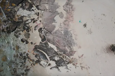
Drones and Artificial Intelligence are uncovering ghost nets from 50 centimetres to larger than five metres along the coastline of the Gulf of Carpentaria, proving the success of a program aimed at maintaining the pristine environment of this region.
The project, led by Charles Darwin University’s (CDU) North Australia Centre for Autonomous Systems (NACAS) in partnership with the Anindilyakwa Land and Sea Rangers, began surveys last year with the goal of mapping the distribution of ghost nets washing ashore the Anindilyakwa Indigenous Protected Area (IPA), which covers nearly 1000 km of NT coastline.
To date, 83.74 km of remote coastline has been surveyed, detecting 72 nets of varying size and condition.
Ranger Manager Kirsten Eden explained helicopter surveys are traditionally used to monitor ghost nets, but this approach is expensive and often restricted by the wet season.
“With CDU, we’ve successfully used drones to map the most affected beaches within the IPA, enabling more efficient planning, targeted net removal, and improved marine debris assessments using up-to-date data,” Ms Eden said.
The project is funded by a Ghost Nets Innovative Solutions Grant, provided by the Australian Government through Parks Australia.
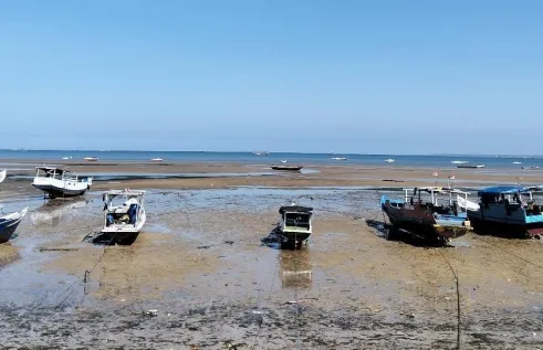
To support on-ground response efforts, the Rangers also use a purpose-built vessel, Jarrangwa—funded through the same initiative—to access remote locations for net retrieval.
The detected ghost nets ranged from small 50-centimetre fragments to large intact nets over five metres long, with some partially buried and barely visible from the ground. Several of these buried nets were like icebergs—much larger beneath the surface—requiring a winch to extract them or a team of three to five people to dig them out and load them onto the vessel.
CDU PhD candidate Aliesha Hvala said drones were of strategic and efficient benefit to surveying Northern Australia, one of the country’s most ecologically significant regions and most remote.
“Drones offer a user-controlled aerial monitoring solution, particularly suited to northern Australia, where survey efforts are often limited by accessibility and seasonality,” Ms Hvala said.
Anindilyakwa Land and Sea Ranger – Aquatic Biosecurity Officer Benjamin McArdle affirmed how useful drone and AI technologies have been to detecting ghost nets.
“High-resolution images combined with precise GPS coordinates of ghost nets has greatly improved the efficiency of trip planning,” Mr McArdle said.
“It allows the team to map out routes and identify suitable beach access points before leaving the boat ramp.”
Alongside detecting ghost nets, another outcome of this project is building the technical capabilities of rangers on Country.
The Ranger team completed the nationally accredited Certificate III in Aviation (Remote Pilot), delivered on Country by CDU and funded through the Australian and Northern Territory Governments' Fee-Free TAFE (NT) program.
This training provides the necessary qualifications and experience to operate drones in compliance with Civil Aviation Safety Authority (CASA) regulations.
Louise Mountford is one of the rangers who accessed this training, and planned to apply these skills and knowledge to her work.
“I found the Certificate III very challenging, but in the end, I learnt so much from it,” Ms Mountford said.
“I wasn’t very comfortable doing it [flying drones], but I had the right people around me to overcome that and I’m very grateful.
“When you’re walking on the ground you can’t see everything, but with the drone it can help us see so much better.”
Ms Eden said the Ranger team was now well-equipped to conduct drone mapping independently, but emphasised the importance of ongoing investment to maintain and expand this capability.
“We have been fortunate to access CDU’s equipment for the initial mapping,” Ms Eden said.
“We will need funding opportunities for the initial purchase of our own drone equipment, continuous upskilling and training of Indigenous Rangers, and the resources to process and store the collected data on Country.”
Another round of broad-scale surveying is scheduled to take place in the coming weeks.
Related Articles
Reasons for illegal fishing “more nuanced” than previously thought, international research shows
A resurgence of illegal fishing in northern Australian waters is cause for environmental, biosecurity and social concern, and new research suggests the causes of this activity are increasingly complex.
Read more about Reasons for illegal fishing “more nuanced” than previously thought, international research shows
Australia mapped into global sharks and rays database
A global database documenting the location of critical habitats for sharks, rays, and chimaeras has recently expanded to include Australia, with years of extensive research by Charles Darwin University contributing to this crucial digital record.
Read more about Australia mapped into global sharks and rays database
On the road to cheaper, safer commutes with CDU’s new research hub
The Northern Territory is on the road to smoother, safer commutes with innovative support and research from Charles Darwin University’s (CDU) new Centre for Asphalt and Road Technologies (CART).
Read more about On the road to cheaper, safer commutes with CDU’s new research hub


